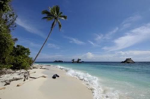
National Park Bromo Tengger Semeru


National Park Bromo Tengger Semeru has a type of sub-montane ecosystems, montane and sub-alphin with trees large and hundreds of years old.
Some plant species found in the National Park Bromo Tengger Semeru include jamuju (Dacrycarpus imbricatus), mountain pine (Casuarina sp.) Eidelweis (Anaphalis javanica), various species of orchids and rare species of grass (Styphelia pungieus).
There are approximately 137 species of birds, 22 species of mammals and 4 species of reptile in this national park
And protected rare animals found in national parks, among others, mongoose (Pardofelis marmorata), deer (Cervus timorensis), long-tailed macaque (Macaca fascicularis), deer (Muntiacus muntjak), red jungle chicken (Gallus gallus), leopard (Panthera pardus), ajag (Cuon alpinus), and various species of birds such as alap-alap birds (Accipiter virgatus), hornbill (Buceros rhinoceros silvestris), bido serpent eagle (Spilornis cheela bido), black thrush (Dicrurus macrocercus), Scaly-breasted falcon (Haliastur indus), and grouse that live in Ranu Pani, Ranu Regulo, and Ranu Kumbolo.
Park Bromo Tengger Semeru National Park is the only conservation area in Indonesia, which has a unique form of sea sand covering 5250 hectares, is located at an altitude of ± 2100 meters above sea level.
In the sea of sand in the central seven eruptions in the two paths that criss-cross from the east-west and northeast-southwest. From the northeast-southwest is Mount Bromo emerged which included the active volcano which at any time can remove the eruption of smoke and threatening human life in the surrounding (± 3500 inhabitants).
Mount Bromo has a crater with a diameter of ± 800 meters (north-south) and ± 600 meters (east-west). While the danger area of a circle with a radius of 4 km from the center Bromo crater.
Tenggerese around the national park is a tribal Hindu. According to legend, the origin of these tribes from the kingdom of Majapahit who lives in exile. Uniquely, seeing people around (my Su-Tengger) was no sense of fear despite knowing it was dangerous Mount Bromo-yes, including many tourists who visit the National Park Bromo Tengger Semeru at Kasodo Ceremony.


Sumbawa is located between Lombok and Flores islands, including in East Nusa Tenggara province. Major cities in this region is Sumbawa Besar and Bima. Sumbawa surrounded by many bays, such as the Bay of Saleh, Dompu, Bima and Woworanda. Saleh Bay north of the Peninsula Studios have long and 75 km 30 km wide. The world knows that beauty resort Sumbawa. Princess Diana had visited during his lifetime Sumbawa, where he visited the island of Moyo.
Moyo Island is located 15 kilometers from the northern edge of the island of Sumbawa. Area of 31,500 hectares, better known as bird park. Another thing that makes Sumbawa is famous eruption of Mount Tambora in 1815 which makes this area became the subject of research vulcanology, geology and biodiversity.
There are two large and famous kingdoms in this region, namely Sumbawa Besar. Palace are still strong and around 115 years old is made of wood in 1815 and called Dalem Loka. The building is supported by pillars of traditional style and decorated with carvings that are not uncommon. The second kingdom is in the store Bima extraordinary collection of beautiful, like a royal crown, kris-kris with gold jewels plus bertakhtakan handle made of ivory. If you want to see the collection, of course, should contact the local government first. Also Taliwang Lake located in West Sumbawa is also interesting to visit with typical food, like chicken that tastes spicy TALIWANG and steady it. Discover traditional weaving centers Sumbawa making a hue and has a distinctive color.
Sightseeing options are Maluk Beach, no less to the beach of Kuta and Sanur in Bali. This beach is also easily accessible from the capital of West Nusa Tenggara, Mataram. From here you can see the beauty of the Gulf waves Maluk often used as surfing arena. No wonder the world-class surfers always an agenda of activities at the Beach Maluk.
Komodo Island is still in an area of Sumbawa Island National Park Area (KTN) Komodo with area covering 173,300 acres. In this Commission there are three large islands of Komodo (33,937 hectares), Rinca (19,625 hectares) and Padar (2017 ha) plus several other small islands. Komodo most undulating with an altitude 735 m peak of Mount Ara. To reach this island can be through Labuan Bojo Flores
If you are interested to see commodity in the Commission, you must go in groups / teams and each team led one or two national parks officers. As a walk in the Commission you must stay with your team. During the trip in this area you will find the loss of one's memorial. Several years ago a foreign tourist missing for a walk alone in the Komodo Park. Komodo is the highest predators on the island, daily food is goats, deer and horses.
One of the island which still includes the island of Komodo Commission Rinca, in contrast to the island of Komodo, Rinca island is rarely visited by tourists. Population on the island of Komodo dragon is not in Komodo, but Komodo dragon in this area are more aggressive because people rarely see. Komodo addition, in this island there are also horses and wild buffalo living in the habitat.
Occasionally create different holiday rasaya legitimate. So, make Sumbawa as your next destination.
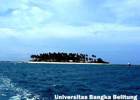
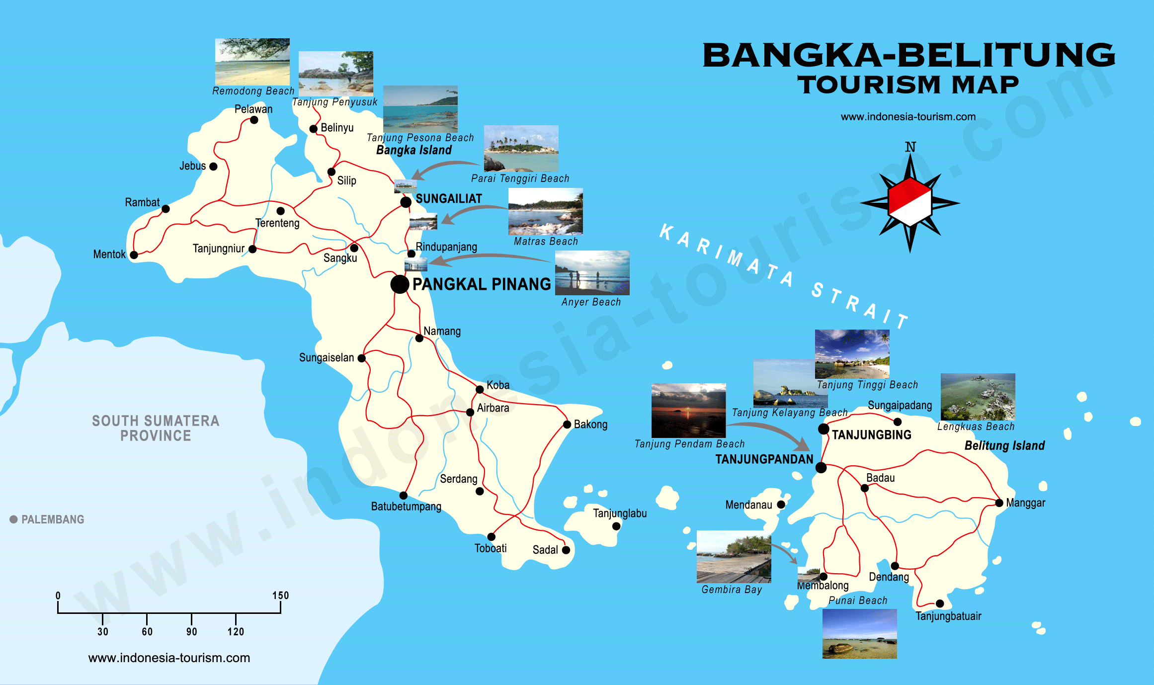
Bangka–Belitung Islands is a province of Indonesia, which includes two main islands, Bangka and Belitung, and several smaller ones that lie from the east of Sumatra to the northeast of South Sumatra province. The Bangka Strait separates Sumatra and Bangka, and the Gaspar Strait separates Bangka and Belitung. The South China Sea is to the north, the Java Sea is to the south, and Borneo to the east is separated from Belitung by the Karimata Strait.
The province was formerly part of South Sumatra, but became a separate province along with Banten and Gorontalo in 2000. In 2004 its population was 1,012,655. The capital is Pangkal Pinang.
These islands have significant mining (the largest producers of tin in Indonesia). They also produce white pepper CPO etc.
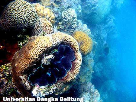
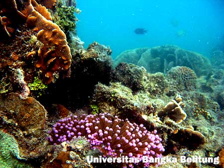
Bangka Belitung also has many beaches and smaller islands which have attracted tourists from around the world. The famous beaches are Matras beach, Parai beach, Tanjung Pesona beach, Batu Bedaun beach, Remodong beach, Pasir Padi Beach, Tanjung Kelian Beach, Rebo beach, Telok Uber Beach and many others.
Bangka-Belitung is divided into six regencies (kabupaten) and 1 city (kota):
- Bangka (regency seat: Sungailiat (town))
- West Bangka (regency seat: Muntok)
- South Bangka (regency seat: Toboali)
- Central Bangka (regency seat: Koba)
- Belitung (regency seat : Tanjung Pandan)
- East Belitung (regency seat: Manggar)
- Pangkal Pinang (city)


Kerinci Mountain
Tuo gravel in this village there are many inns are run by local residents. Residents in this village Tuo grit is the Javanese majority who have lived there a long time, since the Dutch colonial era.
Mount Kerinci is under the protection of Nasioanal Park Kerinci Semblat. On this mountain forest areas we still can find a tiger sumatera. One thing that should be in mind, if you climb this mountain, do not spend the night or put up tents in the area I or area selter altitude below 1500m above sea level.
Because this area is sumatera tiger habitat and where they hunt. And try not to bring food or rancid smell of raw meat.
The view from the summit of Kerinci a compelling, we can see the lake and the lake situjuh KERINCI above the top of the hill situjuh, and in the south looks Lubuk Gadang and Labuh Estuary.
While in the west Indian Ocean visible. very beautiful. Mount Kerinci can be achieved through Jambi city or town of Padang, or also from Muara Bungo. Muara Bungo is located in Sumatra Cross road between the provinces of Jambi and West Sumatra.
Route
- Pondok R10 (1611 m above sea level) - Door Woods (1800 m above sea level).
R10 is a guard shack TNKS hall to watch every visitor who will climb the mountain Kerinci. Terrain of the plantation / farm population, good road conditions (asphalt) to the forest boundary. Mileage 2 km or 1 hour drive.
- Door Rimba - Post Bench Long (1909 m above sea level).
Doors Woods is climbing in the starting gate in the forest boundary between heterogeneous fields and forests as the entrance, here there is also the location of shelter and water approximately 200 meters to the left if we are facing a mountain of Kerinci.
Mileage to the Bench Length 2 km or 30 minutes travel, trekking path is relatively flat.
- Post Bench Length - Pos Batu Pond (2000 m above sea level).
Heading length bench there are two shelters that are practically feasible. Towards the Stone Moss still climbing sloping terrain and distance of about 2 km with 30 minutes travel time.
- Post Rock Pond - Shelter 1 (2225 m above sea level).
Moss Stone heading a place to rest but there is no shelternya but here there is the location of the water (sludge water). It is located on the river but the river is the only watery konterporer rainy season.
Shelter mileage to 1 as far as 2 km trip with travel time 1 hour. The condition is relatively steep trails with a slope of about 60.
- Shelter 1 - Shelter 2 (2510 m above sea level).
Shelter 1 is a place of rest, consists of one hut is still well maintained, mileage to post 2 of 3 km with a 1.5-hour travel time. On this path occasionally steep path up the slope 45.
- Shelter 2 - Shelter 3 (3073 m above sea level).
Shelter 2 is a place of rest, with one shelter, but not too strong. Perhaps because of age is quite an old cottage and conditions of the temperature field dratis make this shelter survived, although in a state tilted almost collapsed.
Mileage to the shelter 3 is 2 km with a 2-hour travel time.
- Shelter 3 - Shelter 4 (3351 m above sea level).
Shelter 3 is the only place to rest just tingga iron framework. This location is an open field and can look towards the village of gravel Tuo.
This place is too good to be a place set up a tent. because of the fairly flat area. Here also we can find the source of water. The journey to the summit was only a 3 hour drive from this shelter.
Toward shelter 4 distance of 1.5 km with a 1-hour travel time. Condition of walking trails are former water flow into the ascent path.
- Shelter 4 - Limit vegetation / Sand / Stone Rocks - Peak (3800 m above sea level).
This place is a bulletin board that contains prohibitions establish new routes and information about the path of sand and rocks please be careful.
Broad field. Here can be set up tents as long as your tent to meet the requirements established here, because here the wind was blowing quite hard and cold temperatures.
LICENSING
Permitting for climbing this mountain, including standard and not too complicated. Could permit the Postal maintained national park ranger.
PLACES OF INTEREST
There are some interesting places that might be visited include:
- Kebon tea Tuo grit
- Lake Belibis
- Lake KERINCI
- Lake Situjuh mountain Situjuh
Also on the site Kerinci Seblat National Park also contains the so-called community KERINCI PEOPLE. This community until now is still very difficult to find. French anthropology team is still investigating. According to locals, this KERINCI people have high posture children aged 3 years and had long hair.
Unique from them is their feet upside down, not like we are behind the heel but the heel is this KERINCI front and fingers facing backward.
Their movement is very fast, fast sangking french photograper investigators could not take pictures of them even had to face. The results of the investigation team this French anthropologist can be seen at their offices in the city full River. There are photos of their footprint as big as the palm of a child's foot.


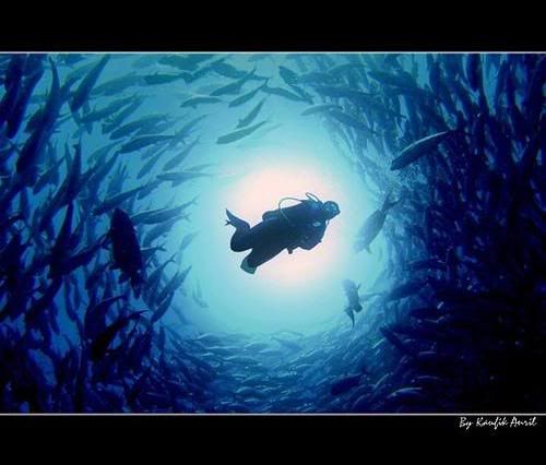
Bunaken fascinating
With held Sail Bunaken 2009, the Indonesian people also have an opportunity to mobilize world opinion and assertion that Indonesia is the largest maritime countries in the world that has tremendous potential for marine and maritime power to be proud of.
This is the Marine Park to be proud of it, ...


Raja Ampat Islands
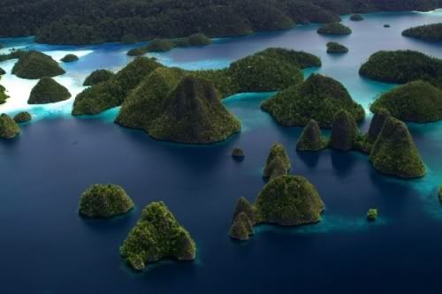
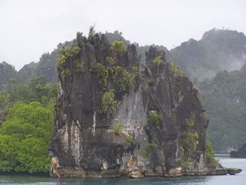
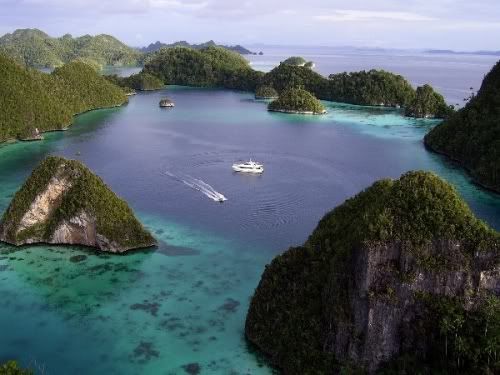
The archipelago is an archipelago located in the western province of Papua on the island of Irian Jaya Barat, exactly at the head of birds of Papua. This archipelago is a divers destination-divers who are interested in the beauty of underwater scenery. Four of the group of islands is the largest island, namely:
1. Island Waigeo
2. Island Misool
3. Salawati Island
4. Island Batanta
The archipelago is a place of great potential to serve as objects of tourism, especially diving tourism. Raja Ampat Islands waters according to various sources, is one of the 10 best waters for diving sites around the world. In fact, it may also be recognized as number one for the completeness of flora and fauna under the water at this time.
Unique species that can be found at the time of diving are some of the pigmy seahorse species or mini kudalaut, wobbegong and manta ray. There is also a fish endemic to the Raja Ampat, namely Eviota king, the kind of fish gobbie.